


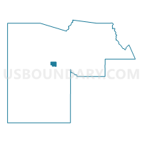
LIBERTY Voting District, Maricopa County, Arizona
About
Outline

Summary
| Unique Area Identifier | 524844 |
| Name | LIBERTY Voting District |
| County | Maricopa County |
| State | Arizona |
| Area (square miles) | 21.79 |
| Land Area (square miles) | 21.79 |
| Water Area (square miles) | 0.00 |
| % of Land Area | 100.00 |
| % of Water Area | 0.00 |
| Latitude of the Internal Point | 33.39175920 |
| Longtitude of the Internal Point | -112.50522860 |
Maps


Graphs
Select a template below for downloading or customizing gragh for LIBERTY Voting District, Maricopa County, Arizona


Neighbors
Neighoring Voting District (by Name) Neighboring Voting District on the Map
- BUCKEYE 1 Voting District, Maricopa County, AZ
- BUCKEYE 2 Voting District, Maricopa County, AZ
- DURANGO Voting District, Maricopa County, AZ
- ESTRELLA FOOTHILLS Voting District, Maricopa County, AZ
- GILA BEND Voting District, Maricopa County, AZ
- ORANGEWOOD FARMS Voting District, Maricopa County, AZ
- PERRYVILLE Voting District, Maricopa County, AZ
- RAINBOW VALLEY Voting District, Maricopa County, AZ
Top 10 Neighboring County Subdivision (by Population) Neighboring County Subdivision on the Map
- Phoenix CCD, Maricopa County, AZ (2,972,357)
- Buckeye CCD, Maricopa County, AZ (62,196)
- Gila Bend CCD, Maricopa County, AZ (22,116)
Top 10 Neighboring Place (by Population) Neighboring Place on the Map
Top 10 Neighboring Elementary School District (by Population) Neighboring Elementary School District on the Map
Top 10 Neighboring Secondary School District (by Population) Neighboring Secondary School District on the Map
Top 10 Neighboring State Legislative District Lower Chamber (by Population) Neighboring State Legislative District Lower Chamber on the Map
Top 10 Neighboring State Legislative District Upper Chamber (by Population) Neighboring State Legislative District Upper Chamber on the Map
Top 10 Neighboring 111th Congressional District (by Population) Neighboring 111th Congressional District on the Map
Top 10 Neighboring Census Tract (by Population) Neighboring Census Tract on the Map
- Census Tract 506.10, Maricopa County, AZ (7,915)
- Census Tract 506.08, Maricopa County, AZ (7,163)
- Census Tract 507.02, Maricopa County, AZ (5,280)
- Census Tract 507.01, Maricopa County, AZ (5,092)
- Census Tract 506.11, Maricopa County, AZ (4,477)
- Census Tract 7233.04, Maricopa County, AZ (4,230)
- Census Tract 610.19, Maricopa County, AZ (3,161)
- Census Tract 7233.07, Maricopa County, AZ (2,186)